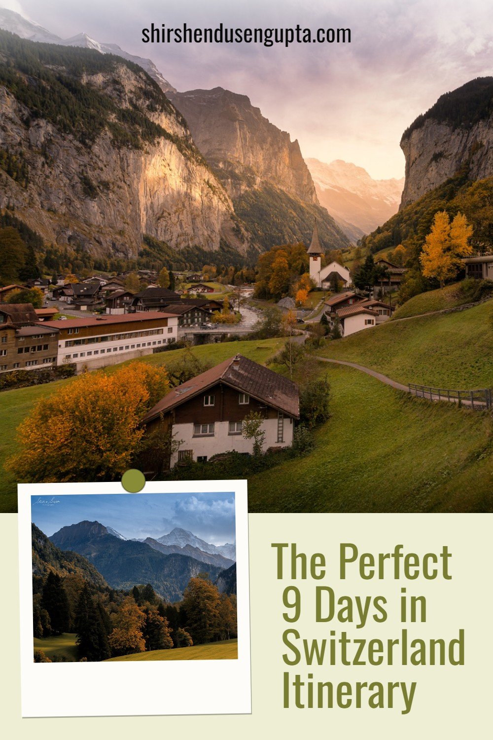
The Perfect 9 Days in Switzerland Itinerary | Ultimate 9 Day Switzerland Road Trip Itinerary | Complete Travel Guide to Best Places to Visit and Top Must See Tourist Attractions of Switzerland

Switzerland - The Land of Enchantment, Peace, and Prosperity
Switzerland, the land bosoming towering mountains, crystal clear turquoise Alpine lakes sculpted by glaciers, and green meadows adorned with humble farms, quaint villages, and historic towns where old meets new, is a destination that inspires passion in outdoor sports lovers, writers, painters, and photographers worldwide. Regardless of your travel destination or activities, Switzerland is guaranteed to offer breathtaking scenery, delectable cheese and chocolate, and effective, user-friendly public transportation. Apart from being enchantingly beautiful, Switzerland is among the most developed nations in the world with the highest nominal wealth per adult, the eighth-highest gross domestic product (GDP) per capita, and the first in the Human Development Index since 2021.
Switzerland was founded in 1291 by an alliance of cantons named the Confoederatio Helvetica, or Swiss Confederation against the Habsburg dynasty, from where the abbreviation/ISO code CH for Switzerland originates. The Peace of Westphalia, signed in 1648, officially recognized Switzerland's independence from the Holy Roman Empire. However, the current nation was not established until 1848, when a new constitution was ratified. Since the 16th century, Switzerland has upheld an armed policy of neutrality and hasn't engaged in hostilities abroad since 1815. As a result, the nation as a whole enjoys peace, prosperity, and innovation.
Switzerland is home to the headquarters or offices of the most significant international organizations, including the WTO, WHO, ILO, FIFA, and UN. It is also the birthplace of the Red Cross. It is a founding member of the European Free Trade Association (EFTA) and a participant in the Schengen Area and the European Single Market. However, it is not a part of the European Union (EU), the European Economic Area, or the Eurozone. It has four primary linguistic and cultural regions - Romansh, German, French, and Italian.
So based on our personal experience of traveling to Switzerland and crossing it during our travels to other countries several times, today I’m going to share with you the tips and tricks on how to get the most of this amazing piece of creation named Switzerland over a period of 9 days. Let the journey begin!
The Itinerary
To me, Switzerland is all about mountains, lakes, waterfalls, Alpine villages, and historic towns. So you need to choose an itinerary combining one or two of each of the above to experience the beauty of Switzerland in its entirety. Also, having too many of each of these may be overkill and turn out to be a very expensive Swiss drama. So, in our itinerary, we chose the best of each of the above to ensure we capture the true essence of Switzerland in our hearts forever, while keeping the itinerary cost-effective. According to our itinerary, we decided to make our bases in 3 locations namely -
Bern - To explore the city of Bern
Interlaken - To explore the Bernese Oberland region comprising the city of Interlaken, the lakes of Thun, Brienz, and Lungern (and some of the castles and villages around them), Lauterbrunnen, Kleine Scheidegg, Jungfraujoch (Top of Europe), and Grindelwald
Lucerne - To explore the Lake and city of Lucerne, Rhine Falls near Zurich, and the Lake and city of Constance.
Note: We did not visit Mount Titlis, but if you wish to, you can travel there from Lucerne.
These are very popular bases for tourists to explore Switzerland across its length and breadth. You may also add Geneva and Zermatt to this list if you wish to explore the lake and the city of Geneva and Zermatt (and Mount Matterhorn), respectively.
Note: Since Zermatt is car-free it’s better to stay in the nearby city of Tasch if you are in Switzerland by car and travel by public transport to Zermatt.
In the map below I have pointed out the main places of our visit and in the article thereafter I’ve shared the day-by-day planning, explanation, and experience of our travel.
Day 1: Hoofddorp (the Netherlands) to Bern (Switzerland)
On an early autumn morning of day 1, we started from our home in Hoofddorp (the Netherlands) and drove 850 km over serpentine Alpine highways in 12 hours (including the breaks) to Bern, the capital of Switzerland crossing Germany on the way. Upon reaching Bern, we checked in to our accommodation and slept off.
Day 2: Exploring Bern
The next whole day we dedicated ourselves to exploring Bern. Renowned as the ‘Gateway to the Alps’ (referring to the Alpine region of Bernese Oberland which’s the highest and southernmost part of the canton of Bern), Bern, the capital of Switzerland, situated on the banks of Aare, a significant river on the Swiss Plateau, is the fifth most populated city in Switzerland after Zürich, Geneva, Basel, and Lausanne. The predominant spoken language is Bernese German, a regional variation of the Alemannic Swiss German dialect, while German is the official language. Bern's ancient old town (Altstadt) was classified as a UNESCO World Heritage Site in 1983.
Even though fortified settlements had existed since antiquity, Berthold V, Duke of Zähringen, from the Zähringer ruling family founded the actual medieval city in 1191. After becoming a free imperial city in 1218, Bern became one of the Swiss Confederacy's eight founding cantons when it joined in 1353. Since then, Bern has pursued a policy of independent territorial development, becoming a sizable city-state and a significant player in Swiss history. Since the fifteenth century, the city has gradually been reconstructed and given its current features. In 1848, Bern was designated as a Federal City.
Morning walk along Kirchenfeldbrucke Bridge, Bern Cathedral, and Parliament Building
We started our exploration by enjoying the best views of Bern from the Kirchenfeldbrucke Bridge, a historic bridge built across the river Aare in 1883. It is an example of Swiss architectural and engineering excellence. A morning stroll on Kirchenfeldbrücke, surrounded by gorgeous scenery, is a lovely experience. As we walked over the Kirchenfeldbrucke Bridge, we were greeted by stunning views of the Parliament Building and the imposing Cathedral of Bern overlooking the Aare Valley. Once we got off the bridge, we walked further to visit the cathedral and the parliament up close.
Cathedral of Bern overlooking Aare Valley
Parliament Building
Strolling through Marktgasse and checking out Schützenbrunnen
From the Kirchenfeldbrucke Bridge, we took a leisurely stroll through the Marktgasse or Market Street, the heart of the lively shopping district of the Old Town of Bern. Wandering around the paved street of Marktgasse, you can the old-world charm of the structures that are now home to shops and restaurants.
At Marktgasse you will also find the Schützenbrunnen (or Marksman Fountain), a 16th-century fountain that honors the ‘Gesellschaft zu Schützen’ (or ‘Target Musket Society’ which was a civil society/guild in Bern until 1799) and features an armed rifleman holding a sword in his left hand, the ‘Society to Shooting’ flag in his right, and a bear cub between his legs pointing a musket toward the entrance of the ‘Society to Shooting's former residence at the fountain's original site. It was constructed out of stone between 1527 and 1543 replacing a stone fountain that stood there.
Schutzenbrunnen on Marktgasse with Zytglogge (Clock Tower) at the backdrop
Walking past Zytglogge (Clock Tower)
Walking a bit further along the Marktgasse we reached the iconic Zytglogge (Clock Tower). Since its construction in the early 13th century, it has functioned as the city gate, guard tower, jail, clock tower, and hub of all sorts of activity. With its tall copper spire, the tower dominates the central city; the astronomical clock workings were added around the time of the Reformation in 1530. This was the official clock in Bern from the 16th to the 19th centuries; all other clocks were adjusted based on it. Huge crowds congregate in front of Zytglogge as the clock approaches the hour to witness the unique show that happens every time. Visitors of all ages are mesmerized by the mechanical figurines, which include Chronos, the God of time, a jester, a golden rooster, and a procession of bears.
Relishing Indian Buffet Lunch at Namaste India City Restaurant
For lunch, we chose the fantastic Indian buffet lunch at Namaste India City Restaurant that included a wide variety of delectable foods such as basmati rice, rajma (kidney beans) curry, dal tadka, alu-bengan (potato and egg plant curry), coconut chicken, a selection of raitas, pickles, chutneys, salads, and desserts like mango kheer. After lunch, we spent the rest of the afternoon exploring every nook and cranny of the narrow bylanes of the historic old town of Bern.
Day 3: Driving from Bern to Interlaken (Tourism Capital of Bernese Oberland), and then exploring Interlaken
The next morning we checked out from our hotel in Bern quite early (when it was still dark) and drove 60 km (in an hour) to reach Interlaken, known to be the tourism capital of the Alpine region of Bernese Oberland. We made Interlaken our base for exploring the Bernese Oberland region and stayed there for 4 nights.
Bernese Oberland
With breathtaking views, striking Alpine scenery comprising countless mountain peaks, 800 glittering lakes, unspoiled wildlife, 350 km of cross-country ski trails, 200 km of hiking trails, and world-class events and activities, the Bernese Oberland region is very aptly dubbed as the ‘Gateway to the Alps.’ The origin of the word "Bernese Oberland" dates back to 1798, when Napoleon established the canton of Oberland, with Thun as its capital. Napoleon himself reunited the cantons of Oberland and Bern five years later with the Mediation Act, but the term remains at large probably as a result of tourism marketing.
There are many sub-regions within the Bernese Oberland, but two worth visiting are the lakeside city of Interlaken and the exhilarating heights of the Jungfrau Region. The Eiger, Mönch, and Jungfrau are the three magnificent peaks that form the center of the Jungfrau Region. There is also a sense of tranquility and tradition in each of the five quaint villages of Grindelwald, Lauterbrunnen, Haslital, Wengen, and Mürren. Below is a railway map of the Bernese Oberland region. The black rectangles represent the places we visited during our stay in the Bernese Oberland region, the red lines represent the railway tracks, and the black lines represent the cable car routes.
Arriving at Interlaken early morning
As we arrived at Interlaken around 08:30 CET, the sun rose over the horizon and peeped through the clouds, the curtain of darkness lifted, the light fog that embraced the road gradually cleared up and we got rendezvoused with the beauty of the Alpine landscape surrounding our B&B (bed and breakfast).
Checking in to our B&B (Bed and Breakfast)
After that, we crossed over a wooden bridge situated on a narrow stream and checked into our Swiss chalet B&B situated right in the middle of the mountainous landscape, draped with the adjacent woodlands adorned with colorful autumn foliage, and a serene ambiance created by the music of the burbling brook close by. After freshening up and relaxing a bit, we went out to explore the city of Interlaken.
Exploring Interlaken, the Tourism Capital of ‘Bernese Oberland’
Out of all of these cities in the Bernese Oberland region, Interlaken might be considered the Bernese Oberland's tourism capital. Interlaken is surrounded by water, as the name suggests, with Lake Thun's deep sapphire shine on one side and Lake Brienz's tropical turquoise tint on the other. From Interlaken, highways and trains ascend into the Bernese Oberland across the Alps. Thus, the majority of visitors to the region begin their journey at Interlaken. Here are a lot of lodging facilities, holiday homes, and dining establishments for visitors.
Visiting Interlaken Monastery and Castle
We started our day by visiting the Interlaken Monastery and Castle. The old Augustinian monastery of Interlaken is situated in the center of the city and was first mentioned in records in 1133. After the reformation, which occurred about 1525, the state of Bern purchased the entire monastery and turned it into a hospital. Currently, the district administrative office of Interlaken-Oberhasli is headquartered there; the Oberland Ost registry office is also housed in the historically significant buildings.
We took a stroll across the grounds to Interlaken Castle and the castle church and admired the Gothic cloister gallery in the old courtyard of the castle church and its amazing 14th-century steeple.
Strolling through the Shopping District (Jungfraustrasse to the Höheweg)
After lunch, we spent the entire afternoon shopping in the shopping district of Interlaken starting from the Jungfraustrasse to the Höheweg street. You can find traditional Swiss mementos along this long promenade that runs between the Interlaken Ost and West stations. These include army knives, watches from Tissot and other brands, and the best Swiss chocolate, including Lindt. Höheweg is also the place to find typical regional goods, natural cosmetics and regional specialties, such as Bernese Oberland arts and crafts.
Day 4: Visiting Lake Thun, Oberhofen Castle, Lake Brienz, Iseltwald, and Lake Lungern
We began our next day by visiting Lake Thun early in the morning just about sunrise. We drove to Interlaken West from our accommodation, parked our car at Interlaken West, and took a relaxing round-trip on the ship from Interlaken West to the town of Thun and back which took around four hours and forty minutes. In the middle, we got down at the Oberhofen Castle, explored it briefly, and jumped back on the return ferry. We had lunch at the restaurant on the ship itself. After that, once we reached Interlaken West, we picked up our car, drove to Lake Brienz to the east of Lake Thun, explored the village of Iseltwald on Lake Brienz, and finished off the day by catching a breathtaking sunset at Lake Lungern further east of Lake Brienz.
Lake Thun
Nestled amidst the majestic Bernese Oberland, the deep blue Lake Thun, the largest lake in the Bernese Oberland offers a glimpse of the well-known Eiger, Mönch, and Jungfrau mountains, along with stunning views of meadows, woodlands, and Alpine pastures. It stretches up to 3.5 km wide and 17.5 km long. The size of its surface is 47.85 km².
There are numerous charming villages surrounding Lake Thun, each with its own unique charm. The village of Aeschi, located above Lake Thun, provides a distinctive viewpoint of the surrounding scenery and the deep blue waters. Sigriswil stands on the other bank, and here visitors can take in the stunning view of the Niesen, or Swiss pyramid. The best places to go if you want a close-up look at the water are Spiez or Oberhofen. Boats make it easy to get to the lakeside villages that are situated on the shore.
We were enthralled by the picturesque mountain scenery that comprised the idyllic villages, the mountain peaks, Niederhorn, Stockhorn, and Niesen, as well as the five imposing medieval castles surrounding the lake.
Oberhofen Castle (Schloss Oberhofen) on Lake Thun
As mentioned above, there are five medieval castles surrounding the lake Thun.
The Thun Castle - Perched atop the Schlossberg and towering over the town, Thun Castle is quite striking.
Schadau Castle - Schadau Castle will mesmerize you with its breathtaking lakefront gardens.
Hünegg Castle - The Hünegg Castle is a fascinating opulent Art Nouveau-styled castle.
Oberhofen Castle - You can't miss the picturesque view of Oberhofen Castle when you're standing close to the Oberhofen landing stage.
Spiez Castle - Built in Europe's most beautiful bay, the Spiez Castle is located on the diagonally opposite side of the lake to the Oberhofen Castle.
We chose one out of these five to visit which was the Oberhofen Castle as it was closest to the shore. The charming castle complex has a colorful past and dates back to around 1200. The aristocratic de Pourtalès family of Neuchâtel, Prussia, purchased the castle in 1844 and transformed it into a summer home, giving it its current aspect. Within the castle, a museum honoring the memories of past occupants was founded in 1954. The castle grounds are designed as a magnificent English park with breathtaking views of the Bernese Alps making it one of the most beautiful gardens in the Bernese Oberland. You can explore the park's conifers, deciduous trees, and exotic redwoods as you stroll between the vivid blossoms. The gravel court surrounded by lime trees has a play area that is available to children today.
Lake Brienz
Tucked between two massive mountain ranges in the heart of the Bernese Oberland, the turquoise-hued Lake Brienz measures 2.8 km in width, 14 km in length, and 29.8 km² in surface area. Lake Brienz's vivid turquoise color is caused by microscopic sediment particles that the Lütschine and Aare glacial rivers deposit into it. The lake's cleanliness simply serves to accentuate the amazing visual impact created by these incredibly small glacial particles sinking very slowly.
We drove to one of the best viewpoints on Lake Brienz (GPS coordinates: 46.71164, 7.96264) where the famous piano scene of the highly-rated romantic comedy adventure Korean TV Series ‘Crash Landing on You’ was filmed. For those who have not seen the series, I highly recommend it on Netflix. It is about a lady Yoon Se-ri, the owner of a well-known fashion brand from South Korea, who after a horrific paragliding accident, gets stuck in North Korea and meets Ri Jeong-hyeok, a trustworthy military captain. Se-ri learns about the difficulties of life in North Korea while she is there, and as she gradually grows to love Captain Ri, it is up to her and her other North Korean comrades to figure out how to return to the South while keeping their love a secret. The plot is very original and acting commendable. You must watch it if you are into romantic K-Dramas!
However, we did not take pictures at the exact viewpoint since we found it pointless to pay 8 CHF (Swiss Francs equivalent to 8.5 Euros) per person to get on a small bridge with a long queue while there were plenty of good viewpoints close by. So we took pictures of the lake from the shore around the filming location.
Iseltwald by Lake Brienz
After taking pictures of the lake, we explored the adjacent village of Iseltwald on foot. Situated on the southern shores of Lake Brienz, this village is akin to a fairytale encircled by the Swiss Alps, with Lake Brienz at its doorstep. Since Iseltwald is not a large town with lots of shops, this tiny hidden treasure could be the ideal location to go if you want to get away from the crowds and visitors. You can find beautiful gardens and typical Swiss chalets with exquisite architecture in the area. If you ask me, I would say you should choose a peaceful area in Iseltwald and just sit there gazing out over Lake Brienz.
Lake Lungern
Lake Lungern, also known as Lungernersee, is a pearl in the canton of Obwalden that was formerly a naturally occurring lake and is now used as a reservoir to produce power. Its natural character still predominates despite the dam. Lake Lungern was most likely created by a landslide that blocked up the mountain water. It is ideal if you're searching for a peaceful location to witness a calm sunset. There are plenty of places to relax here, and even take a scenic walk along the lake in solitude, even though the lake is located on the road and is easily accessible by car. After enjoying the sunset here, we drove back to the center of Interlaken for dinner and then went back to our B&B to sleep off.
Day 5: Visiting Jungfraujoch and Exploring Lauterbrunnen
Visiting Jungfraujoch
The next morning we decided to visit Jungfraujoch as any trip to Switzerland is incomplete without it. But before we get into the details of the journey, let’s first understand what are the meanings of the terms Jungfrau, Jungfraujoch, Jungfrau Railway, Jungfraujoch Railway Station, and Top of Europe, as these similar terms may be quite confusing for the uninitiated.
Mount ‘Jungfrau’ is a peak in the Bernese Alps and a part of Jungfrau-Aletsch UNESCO World Heritage Site. The three mountains that make up the Bernese Alps are referred to as the "Big Three": the Jungfrau, Mönch, and Eiger. Standing at a majestic height of 4,158 meters (13,642 feet) Jungfrau is the third highest mountain in the Alps, after Mont Blanc and Monte Rosa. The name Jungfrau, which translates to "maiden" in German, comes from the mountain's snow-capped, white peaks.
‘Jungfraujoch’ is a glacier saddle, or ridge, situated on the upper snows of the Aletsch Glacier at an altitude of 3,463 meters (11,361 feet) above sea level, that links the Jungfrau and Mönch summits. It is served by the tallest railway in all of Europe, the ‘Jungfrau Railway.’ It began operation in 1912 and stretches 9 km from Kleine Scheidegg station, passing through the Eiger and Mönch partially underground via a tunnel. With a height of 3,454 meters (11,332 feet), the ‘Jungfraujoch Railway Station’ is the highest public railway station in all of Europe and hence marketed as the ‘Top of Europe.’ It is attached to the ‘Top of Europe’ building, which houses the world's highest Ice Palace, the world's highest chocolate shop named ‘Lindt Swiss Chocolate Heaven,’ the highest post office in Europe with its own area code (3081), one of the world’s highest astronomical observatories named the ‘Sphinx Observatory,’ numerous stores, restaurants with panoramic views, and exhibition spaces. It also serves as the beginning point for several hiking routes, including the ‘Top of Europe’ Trail that ascends to the Jungfrau summit.
Now that you understand what Jungfrau, Jungfraujoch, Jungfrau Railway, Jungfraujoch Railway Station, and Top of Europe are, let me tell you more about the journey. On this day, we did not take our car out of our B&B. We first took a train from the Interlaken Oost train station to Lauterbrunnen (which is a village situated in a valley and known to be the ‘Most beautiful village in Switzerland’) about which we will speak later in this article. Then from Lauterbrunnen, we took the ‘yellow’ train to Kleine Scheidegg train station where we changed to the ‘red’ Jungfrau Railway train that went over the ground for a while and then entered an underground tunnel to pass through the Eiger and Mönch to finally reach the Jungraujoch Railway Station. We disembarked there and entered the connected ‘Top of Europe’ building, which has several floors. We took the elevator to each floor to visit exhibitions like ‘Alpine Sensation,’ the ‘Ice Palace’ where several statues created of ice were displayed, bought some Swiss souvenirs like a cowbell and some Swiss chocolates for my son, visited the viewing platform from where we could see the Jungfraujoch glacier saddle, and finally had an awesome yet expensive Indian lunch at the ‘Bollywood Restaurant.’
Through the images along with the annotations below, I’ve tried to provide you with a visual perspective of our journey.
The ‘yellow’ train traveling from Lauterbrunnen to Kleine Scheidegg
Traveling by the ‘yellow’ train from Lauterbrunnen to Kleine Scheidegg
‘Yellow’ train arriving from Lauterbrunnen to Kleine Scheidegg train station and the ‘red’ train leaving for Jungfraujoch
Traveling by the ‘red’ train from Kleine Scheidegg to Jungfraujoch
View of a mountain lake while traveling from Kleine Scheidegg to Jungfraujoch
Up close view of Jungfrau while traveling from Kleine Scheidegg to Jungfraujoch
View of the Jungfraujoch glacier saddle connecting Jungfrau and Mönch mountains from ‘Top of Europe’ viewpoint
Ice statues of cats in the Ice Palace at ‘Top of Europe’ building
Exploring Lauterbrunnen
After visiting Jungfraujoch, we took the ‘red’ train back from the Jungfraujoch Railway Station to Kleine Scheidegg and then changed to the ‘yellow’ train to arrive back at Lauterbrunnen. We decided to spend the rest of the day at Lauterbrunnen until sunset and then go back to Interlaken.
Situated at 795 m (2608 feet) above sea level between monumental rock walls and mountain peaks, Lauterbrunnen (meaning “many fountains”), dubbed as the ‘Most beautiful village in Switzerland,’ is one of the most striking trough valley villages in the Alps. With the sun peeping through the mountains, over the vibrant Alpine meadows, dotted with Swiss chalets and a secluded church with the soothing sound of 72 waterfalls around, you will become one with nature in this ambient location.
The Staubbach Falls is the most well-known of the 72 waterfalls in the Lauterbrunnen Valley. One of Europe's tallest free-falling waterfalls, it plunges about 300 meters from an overhanging rock wall. It inspired the German poet Johann Wolfgang von Goethe to write his famous poem "Song of the Spirits over the Waters" in 1779. You can get up close to the waterfall via a staircase built next to the waterfall. Another beautiful waterfall is the thunderous Trümmelbach Falls tucked up between massive rock cliffs on the "Black Monk." At a height of around 200 m (656 feet), ten glacier falls produce up to 20,000 liters of water falling over them per second. The only way to see this extravaganza is via tunnel lift during the summer which we couldn’t do since we were there in autumn.
Numerous tours originate at Lauterbrunnen. There are lots of mountain bike and hiking paths to explore in the summer. In winter you can go skiing at the neighboring Mürren-Schilthorn and Kleine Scheidegg-Männlichen ski resorts. The Schilthorn to Lauterbrunnen is one of the longest ski runs, descending almost 2,000 meters in elevation difference. There are about sixteen kilometers of cross-country ski routes beside the freezing waterfalls at Lauterbrunnen.
Kirche Lauterbrunnen (Church of Lauterbrunnen)
Postcard Pic of Lauterbrunnen with the Kirche and Staubbach Falls at the backdrop from Fuhren Point (GPS Coordinates: 46.594874, 7.908382)
Witnessing the sunset from Im Rohr bridge (GPS Coordinates: 46.59357, 7.90889)
Day 6: Exploring Grindelwald
The next day we drove to the Eiger village of Grindelwald and explored the whole area throughout the day at a casual pace partly by car and partly by walking. Grindelwald is the largest ski resort in the Jungfrau region and one of the most well-liked and diverse holiday and excursion destinations in Switzerland because of its mountainous landscape and abundance of lookout points and activities.
If you are here during summer, you can choose among the 300 km of walking trails. One of the most breathtaking walks in the area is the high-altitude trek from Grindelwald-First across the Bachalpsee to the Faulhorn Mountain Hotel and then on to the Schynige Platte. Alternatively, a short stroll from the Männlichen up onto the Kleine Scheidegg offers breathtaking views of the three great mountains of the Bernese Oberland: the Eiger, Mönch, and Jungfrau. You can also visit the peak ‘First’ by taking a cable car from Grindelwald Valley Station.
And if you are here during winter, you have a plethora of options for skiing. There are 160 km of pistes spread between the two ski areas of the peak First and Kleine Scheidegg – Männlichen – Wengen, with about 30 lifts that go to a height of 2500 m (8202 feet). Reaching a height of 2971 m (9747 feet), the Schilthorn near Mürren is a part of the Jungfrau region's ski arena. But without a doubt, the Lauberhorn piste in Wengen—made famous by the World Cup circus—is the most breathtaking in the area.
View of Schreckhorn and Eiger from Grindelwald (GPS coordinates: 46.62600, 8.01315)
Day 7: Driving from Interlaken to Lucerne, and then exploring Lucerne
The next day we checked out of our B&B in Interlaken, drove 70 km in roughly 1.5 hours, and checked into our hotel in Lucerne. We made Lucerne our base for exploring the Lucerne, Zurich region, and Lake Constance for the next couple of days. After checking in, we headed out to explore the center of Lucerne on foot for the rest of the day.
Lucerne
Situated strategically on Lake Lucerne and Reuss River, about an hour from the Zurich airport, Lucerne, the capital of Lucerne canton serves as the entry point to central Switzerland and is surrounded by a striking mountain range. Travelers traveling through central Switzerland often stop in the town due to its various attractions, good shopping, scenic lakeside location, and close proximity to the Rigi, Pilatus, Titlis, and Stanserhorn excursion mountains. The city is home to many lovely examples of medieval architecture, castles, well-known clocks, chocolate manufacturing, and parks. You can meander through historic alleyways made of cobblestones that open up into charming squares with little fountains and pastel-colored buildings. Everywhere you look are protruding Alpine peaks and a sparkling greenish-blue lake crossed by medieval bridges.
The Benedictine abbey of St. Leodegar (Luciaria), established in the eighth century, is the source of the city's name. Against the wishes of the population, who wanted independence, Rudolf IV of Habsburg (also known as Rudolf I of Germany) bought the monastery and city in 1291. Due to political unrest under Rudolf's heirs, Lucerne joined the coalition in 1332 that the cantons of Unterwalden, Schwyz, and Uri had established in 1291. Following the Battle of Sempach (1386) against the troops of the Habsburgs, the group gained independence. By 1415, Lucerne had either purchased, occupied with force, or gained most of the current canton's land through treaties. It rose to prominence during the Reformation as the head of the Catholic cantons and served as the papal nuncio's residence from 1579 until 1874. The onslaught of Napoleonic soldiers forced the city's aristocratic administration to abdicate in 1798. The Helvetic Republic's capital was Lucerne for a while before it returned to its previous position as the cantonal capital in 1803.
Jesuit Church
We started our Lucerne city exploration from the Jesuit Church situated by the banks of the river Reuss. The Jesuit Church in Lucerne is Switzerland's first sizable Baroque church constructed above the Alps. Ignatius of Loyola established the Jesuit order in 1534, and the organization played a significant role in the Catholic Counter-Reformation, which aimed to stop the spread of Protestantism. Switzerland was mostly a Catholic country until Protestant reformers like Zwingli in Zurich and Calvin in Geneva split it apart. The city council of Lucerne responded by calling the Jesuits to Lucerne in 1573 to start a college. The Jesuits received annual financial help from Ludwig Pfyffer, the mayor of Lucerne, who donated his personal assets to them. In 1577, the Jesuit College of Lucerne was founded in Ritter Palace, a building constructed in 1557 as Mayor Lux Ritter's home.
In 1667, work on the church commenced. The main façade and the church's shell were finished by 1673. Though the inside was not entirely completed, the church was dedicated in 1677. Due to financial difficulties, several side altars remained unfinished, and the high altar wasn't even built until four years later. It took till 1893 to finish the towers with onion-shaped tops. The mid-18th century saw a redecoration of the vault. The inner chapel holds the original robes of well-known Swiss patron Brother Klaus.
Rathaus Stadt (Town Hall)
Walking further by the bank of Reuss we reached the Town Hall which is located on the opposite bank of Reuss. One of Switzerland's most lovely public buildings, this Renaissance construction is recognized as a cultural landmark. Its open arcades facing the Reuss commonly known as the Rathausquai, host Switzerland's best weekly market every Tuesday and Saturday from 06:00 to 13:00.
This spectacular building was designed and built in the Italian Renaissance style between 1602 and 1606 by Anton Isenmann, an architect and builder from Italy. Originally, Kornschütte, the ground floor of the Town Hall, was a trading hall. These days, concerts and exhibitions are held in this cozy area. The first-floor council chamber features large paintings by renowned artists Josef Reinhart and Melchior Wyrsch. The room's magnificent ambiance is enhanced by the 18th-century stove, wall paneling, and vaulted ceiling. Designed in the Empire style by Josef Singer, the Tagsatzung Room is a popular location for registrar office marriages these days.
Kapellbrucke (Chapel Bridge)
Right next to the Town Hall, stands the covered wooden footbridge known as the Kapellbrücke, or Chapel Bridge, which crosses the river Reuss diagonally. The bridge, which gets its name from the neighboring St. Peter's Chapel, is now the oldest surviving truss bridge in the world and the oldest wooden covered bridge in Europe. It is a major tourist destination in Switzerland and the city's emblem.
The octagonal "Wasserturm," which stands 34.5 meters (113 feet) tall from the ground and is part of the bridge complex, is named after the word "water," which means "tower standing in the water." The tower was built around thirty years before the bridge. Over the ages, the tower has served as a jail, torture chamber, municipal archive, and local treasury. The tower is now closed to the public, however, it does have a tourist gift shop and is home to the local artillery association.
The bridge was initially constructed as a component of Lucerne's fortifications around 1365. It protected the town from attacks coming from the south (i.e., the lake) by connecting the old town on the right bank of the Reuss to the new town on the left bank. The bridge was originally almost 270 meters (890 feet) long, but it has since undergone multiple shortenings and river bank replenishments, making it only 204.7 meters (672 feet) long overall.
On August 18, 1993, the Kapellbrücke came dangerously close to burning down, destroying two-thirds of the paintings inside. After that, for a total of CHF 3.4 million, the Kapellbrücke was rebuilt and reopened to the public on April 14, 1994.
Reformed Church of the Canton of Lucerne
After visiting the Jesuit Church, Town Hall, and Chapel Bridge on the banks of Reuss, we took a leisurely stroll towards the city center of Lucerne to reach the Reformed Church of the Canton of Lucerne. Reformed Christians in the Canton of Lucerne are united under the Reformed Church in the Canton of Lucerne. The church constitution governs its mission, organizational structure, and confession. Through its Synod, the church unites the parishes and the cantonal church organization. The eleven parishes of Dagmersellen, Escholzmatt, Hochdorf, Horw, Lucerne, Meggen-Adligenswil-Udligenswil, Reiden, Sursee, Willisau-Hüswil, and Wolhusen make up the Reformed Church in the Canton of Lucerne.
Lion Monument
A 20-minute walk from the Reformed Church of the Canton of Lucerne brought us to the world-famous Lion Monument. Nestled in a rocky grotto in a picturesque park setting, the six-by-ten-meter Lion Monument dedicated to “Helvetiorum Fidei ac Virtuti” meaning "To the loyalty and bravery of the Swiss" was first unveiled in 1821. One of the most well-known sculptors of the time, Danish artist Bertel Thorvaldsen, designed the enormous lion in Rome. Constance-based stonemason Lukas Ahorn then carved the sculpture into the rock face of a disused quarry. The history, interpretation, and political connotation behind the monument have been a tad complex. Let me try to shed some light on it for you.
A regiment of Swiss Guards had been serving the French Royal Household since the early 17th century. On October 6, 1789, at the start of the French Revolution, King Louis XVI and his family were compelled to relocate from the Palace of Versailles to the Tuileries Palace in Paris. During the August 10th Insurrection (1792), rebels overran the palace. After the Royal Family was taken from the Tuileries to the Legislative Assembly for safety, fighting broke out. With limited ammunition, the Swiss Guards were overpowered by larger forces. Approximately 760 Swiss Guards protecting the Tuileries perished in combat or were slaughtered upon surrender. An estimated 200 additional people were slaughtered in the September Massacres that followed or died from their wounds while incarcerated.
A Swiss Guards officer named Karl Pfyffer von Altishofen, who was on leave in Lucerne during the August conflict, went on to write a book about the regiment during the French Revolution. He organized a public subscription to finance a commemorative monument as a result of the significant reaction this book received in Switzerland's conservative circles. In 1818, he started accumulating wealth, mostly from European Royal houses. He hired stonemason Lukas Ahorn to construct the monument at a former sandstone quarry close to Lucerne, and he hired Danish artist Bertel Thorvaldsen to design the image. In the sculpture, the dying lion is shown with a spear pierced through it, covering a shield with the French monarchy's fleur-de-lis; next to him is another shield with the Swiss coat of arms. The names of the officers and the approximate numbers of men who died (DCCLX = 760) and survived (CCCL = 350) are listed in the inscription beneath the sculpture. The project was finished in 1821.
The monument was divisive even before it was constructed because of its political meaning, which exalted the previous regime. The public's reaction was swiftly mixed with admiration, pride in the country, and dissatisfaction at the memorial honoring Swiss citizens who had sacrificed their lives for a foreign ruler. Some liberals in Switzerland even threatened to cut off one of the lion's paws in protest, believing that the representation of Switzerland as a lion looked to celebrate a conservative, counter-revolutionary worldview. Despite the controversy surrounding its political message, the sculpture's craftsmanship has garnered praise from the outset. Today, it is one of the most well-known monuments in the world and a top tourist destination in Switzerland.
In 1880, Mark Twain wrote on the monument: “The Lion lies in his lair in the perpendicular face of a low cliff—for he is carved from the living rock of the cliff. His size is colossal, his attitude is noble. His head is bowed, the broken spear is sticking in his shoulder, and his protecting paw rests upon the lilies of France. Vines hang down the cliff and wave in the wind, and a clear stream trickles from above and empties into a pond at the base, and in the smooth surface of the pond the lion is mirrored, among the water lilies. Around about are green trees and grass. The place is a sheltered, reposeful woodland nook, remote from noise and stir and confusion—and all this is fitting, for lions do die in such places, and not on granite pedestals in public squares fenced with fancy iron railings. The Lion of Lucerne would be impressive anywhere, but nowhere so impressive as where he is.”
Strolling through the City Center of Lucerne
After visiting the Lion Monument we spent the rest of the afternoon taking leisurely strolls through the city center of Lucerne and doing some casual. I’m very picky with attire but was lucky to get 3 pairs of shoes that I liked. It’s very rare ;)
Day 8: Visiting Rhine Falls near Zurich and Lake Constance
The next day we drove 110 km (in 1 hour and 15 mins) to the Rhine Falls near Zurich, and then on another 90 km eastwards (in an hour) to Lake Constance for a day trip from Lucerne.
Rhine Falls
Rhine Falls, the largest waterfall in Europe, presents a breathtaking spectacle to its visitors as 700,000 liters of water cascades over the rocks every second, covering a width of 150 meters (492 feet) and a height of 23 meters (75.5 feet) with a volume of 600 m³ (21,189 cubic feet). This magnificent natural wonder was formed 15,000 years ago during the Ice Age when the tectonic shifts forced the Rhine River into a new riverbed. Today it is the main draw for innumerable tourists from all around the world. An unhindered view of this natural sight is made possible by an adventurous path that includes an elevator that connects Schloss Laufen (Laufen Castle) to the lookout platforms (from where we took the picture below). It's also worthwhile to take a boat to the Rhine Falls basin, and climb the short path to the top of the rock in the center of the falls (but we didn’t want to do it with a child). To be honest Rhine Falls is huge but from a photography standpoint, it’s not as picturesque as the other high waterfalls you can find in Switzerland like the Staubbach Falls in Lauterbrunnen that we spoke about earlier.
Situated on the northern bank, the Adventure Park at Rhine Falls is among the most spectacular rope parks in Europe. You can glide from tree to tree on 11 distinct courses with an amazing view of Rhine Falls, catering to anyone with an inclination for adventure. Unfortunately, we did not have the time to do it. But you can if you have the time.
Lake Constance
After visiting Rhine Falls, we had lunch on the way to our visit to Lake Constance (Bodensee in German) on the Rhine River, the third-largest lake in Central Europe after Lake Geneva and Lake Balaton, at the border of Switzerland, Austria, and Germany. It’s made of Obersee (upper lake) and Untersee (lower lake), two smaller lakes. The entire area of the lake is roughly 564 sq. km (218 sq. mi). It is roughly 65 km (40 miles) long and up to 13 km (8 miles) wide, with an average depth of 90 m (295 feet) and a maximum depth of 252 m (827 feet). After visiting Lake Constance, we spent the rest of the afternoon in the Lago Shopping Center in the city of Constance (or Konstanz) which technically falls in Germany. In the evening we returned back to our hotel in Lucerne driving 190 km (in 2 hours and 15 minutes).
Day 9: Lucerne (Switzerland) to Hoofddorp (the Netherlands)
The next morning, we checked out of our hotel in Lucerne and drove back 850 km in approximately 11 hours (with breaks) to reach our home in Hoofddorp (the Netherlands).
Info, Tips, and Tricks
Choose the right season for visiting Switzerland
Switzerland appears charismatic across all seasons. However, I recommend you to visit during autumn since Switzerland is one of the rare places in Europe where the manifestation of the fall colors is quite spectacular. However, the downside could be that the weather may be tricky. Alternatively, if you want to visit a lush green Switzerland, then summer is your best bet. However, many of the waterfalls including the Staubbach Waterfalls in Lauterbrunnen may have almost none to little water in summer. And, if your main reason to visit Switzerland is to enjoy a skiing holiday, you know which season to travel in.
Choose the right itinerary for exploring Switzerland
To me, Switzerland is all about mountains, lakes, waterfalls, Alpine villages, and historic towns. So you need to choose an itinerary combining one or two of each of the above to experience the beauty of Switzerland in its entirety. Also, having too many of each of these may be overkill and turn out to be a very expensive Swiss drama. So, in our itinerary, we chose the best of each of the above to ensure we capture the true essence of Switzerland in our hearts forever, while keeping the itinerary cost-effective.
Choose the right base for exploring Switzerland
Switzerland may look like a small country on the map, but driving times are often quite high for small distances due to the mountainous terrain. Therefore, it is imperative to choose your base locations diligently to avoid a lot of to and from movement. As mentioned at the start of the article, for our itinerary, we decided to make our bases in 3 locations namely -
Bern - To explore the city of Bern
Interlaken - To explore the Bernese Oberland region comprising the city of Interlaken, the lakes of Thun, Brienz, and Lungern (and some of the castles and villages around them), Lauterbrunnen, Kleine Scheidegg, Jungfraujoch (Top of Europe), and Grindelwald
Lucerne - To explore the Lake and city of Lucerne, Rhine Falls near Zurich, and the Lake and city of Constance.
Note: We did not visit Mount Titlis, but if you wish to, you can travel there from Lucerne.
These are very popular bases for tourists to explore Switzerland across its length and breadth. You may also add Geneva and Zermatt to this list if you wish to explore the lake and the city of Geneva and Zermatt (and Mount Matterhorn), respectively.
Note: Since Zermatt is car-free it’s better to stay in the nearby city of Tasch if you are in Switzerland by car and travel by public transport to Zermatt.
Plan for your health
Switzerland is characterized by a diverse ecosystem and hence a great range of biodiversity. However, many of the wild flora and fauna can infect you with deadly diseases like Tick-borne Encephalitis or Lyme disease (especially if you’re planning to camp in the woods/mountains). So, discuss the places you plan to visit with your physician before your vacation and take precautions/vaccinations accordingly. However in my opinion, if you stick to the towns/cities, you should be fine without them.
Also, I recommend you to check with your physician if you should be traveling to higher altitudes like Jungfraujoch if you have asthma, had a bad COVID, or are a smoker. I visited Jungfrau back in 2013 when I used to be a heavy smoker (I quit smoking and drinking completely in 2014), and I had quite a problematic time after reaching the so-called ‘Top of Europe.’ Also, if you feel any discomfort in breathing at higher altitudes, I advise you to quickly take the next train or cable car to one level down. That will make a lot of difference.
Plan for a motorway vignette for your car
To drive on most motorways in Switzerland, your car needs to have a particular vignette, sometimes known as a sticker or e-vignette. The vignette needs to be stuck to the inside of the windscreen and prominently displayed. So before traveling to Switzerland, make sure your vehicle has the sticker installed. They cost around 40 euros and are valid for 2 years. You can order them online or buy them at the border customs posts when you enter Switzerland or local fuel stations before/after you enter Switzerland. Technically if you are caught without stickers, you will have to pay a fine of 200 Euros along with purchasing the vignette of 40 Euros anyway. We’ve learnt it the hard way around 10 years back when we didn’t know it but that's a story for another day.
Pay in CHF
Switzerland is not in the EU and hence the local currency there is Swiss Francs. Try to use your bank card but pay in CHF rather than Euros when the POS terminal asks for it. You will get better exchange rates.
Try to cook
A trip to Switzerland for a couple of weeks may be expensive. So I recommend to rent an apartment (if you get one for a good price) with a kitchen and at least cooking one meal a day (preferably dinner in the night upon return).
Epilogue
So that brings us to the end of our 9-day road trip itinerary across Switzerland. Please let us know in the comments below if you enjoyed reading this article. And until we meet next time, I wish you merry traveling and happy shooting!
Pin the article
Bookmark the article for reading later!

Want to license/buy photos in the article?
License photos for commercial/editorial use or buy photo prints!
Want us to write an article for you?
Articles for magazines, newspapers, and websites!
Watch our Videos
Check out our videos on our Youtube Channel!
Join the Newsletter
Get updates on our latest articles!
We respect your privacy. Read our policy here.